Waze: Community GPS navigation - Commuting Made Easy


Read in other languages:
Our roads are full of obstacles whether it’s traffic, construction or accidents. Even with the help of Google Maps and GPS navigation it’s not always easy to find your way around them. The maps always seem to be too old even if you buy a brand new GPS device because the maps are not regularly updated.
Waze: Community GPS navigation could be the best solution to all of your driving and navigation problems. Find out if you can make road conditions more predictable with Waze in today’s exclusive test report.
| Reviewed version |
| 2.0.3.0 |
Features & Use
Before I get started with Waze, I would like to take the time to address the Web 2.0 phenomenon. My first experiences with the internet were back in the Web 1.0 days. Back then internet surfers simply consumed the content that was presented to them. Except for the occasional forum it was difficult to share your opinions with others.
The CIO magazine was the first to coin the term Web 2.0 way back in 2003. Over time, the internet has evolved from a static content-based network to an interactive user-generated community.
All sorts of ratings and user rankings started cropping up left and right, including our beloved AndroidPIT forum and community.
Web 2.0 is basically participatory internet where anyone can get involved. Different companies have been jumping on the Web 2.0 bandwagon, creating new and exciting user-generated content. This pooling together of knowledge and opinion from millions of internet users across the globe is becoming a force to be reckoned with. It would be impossible to imagine a site like Wikipedia existing 10 years ago. Nowadays it’s not just encyclopedia’s that are becoming more interactive by the minute.
Waze is based on the same principle: the app seeks to use information generated from millions of users to create the most up-to-date road maps possible.
How does it work?
The idea is so simple, it’s genius! When the Waze app is running on your phone, your location is automatically transmitted to the Waze server. Step by step this creates an accurate map – all completely automatically! Using information pooled from different users Waze can see patterns to tell where the following are located:
- City streets: All streets within a town or city have a certain speed limit (25/35/45 mph). Waze can easily figure where a specfic street is located. Moreover, Waze can tell whether you are driving in a residential area or on a city thruway including the location of streetlights.
- Highways: Same deal as with normal streets
- Subways and Trains (coming soon): Since subway trains run at a stable speed and stop at specific stops, Waze can see where subway lines are located by tracking the community’s movement.
In a nutshell, Waze maps are created by passively keeping tabs on users. All you have to do is keep Waze turned on.
How do I benefit from it as a user?
First off, I’m not a really user yet because I’m still helping the app to generate map content for future users. When enough people start using it, however, Waze becomes an essential tool for drivers and commuters worldwide! More Waze users means better maps. The information is compiled:
- Automatically
- User-based
Examples:
- Road closures due to construction? Waze lets you know about it! If you notice that Waze users have stopped moving along a street or highway, it’s a pretty safe bet that something has gone wrong. If Waze receives notifications from multiple users, it can tell people to avoid a certain street
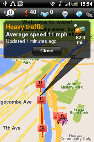
- Find out about traffic jams in advance: Traffic jams can cost you valuable time and nerves. It doesn’t have to be this way any longer. Jams occur for the most part (except for accidents) when too many cars merge onto a street at different speeds. The interesting part is that you can predict bad traffic with live information on the speed of all the cars around you. Waze can do that for you. You can know about traffic jams ahead of time if there are a lot of active Waze users on the road.
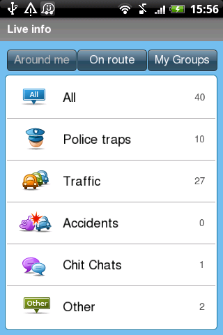
Other dangers: Police traps, accidents, speed cameras…Waze keeps tabs on all of these things with the help of its community.
Also: There are mechanisms in place to prevent any abuse or spreading of false information across the community. It takes a minimum of five notifications about something for it to actually be shared with the community. Either that or the notification has to come from a “trusted Wazer”. I can’t tell you exactly how this works because I don’t know all the ins and outs of this app. Based on the overwhelmingly positive reviews of Waze on Google, it is safe to say that these mechanisms really work.
The Communal Spirit
As I said before, Waze lives from its community! This app requires a lot of active participation to actually work. That’s why Waze has some special community features in order to encourage people to remain active.
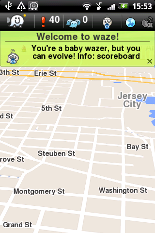
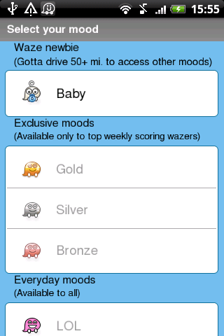
- Status: Every user has a ranking, a score and an emoticon with which you can express your mood. Wazers that have driven less than 80 kilometers (50 miles) with Waze start out as “babies”. After that you can select an individual emoticon for all other users to see on the map in real time. The best Wazers of the week can show off their gold, silver or bronze status on the map.
- Ping: You can ping other Wazers i.e. you can send them a short message.
- Groups: In addition you’ll find different groups that you can join. There are groups geared towards specific commuters. I can create my own groups or join in with others.
Bottom Line:
I’m a huge Web 2.0. fan! It’s kind of a no-brainer given the fact that I’m an active AndroidPIT blogger and writer. But I seriously think that the Internet has the capability to combine great programming with active users in order to create amazing things! It just makes sense to apply the Web 2.0 to navigation. It’s long overdue, actually, because traffic is constantly changing and very hard to keep up with.
Waze still needs a lot more users to become truly effective, but it’s on the right path.
My tip: check out Waze: Community GPS navigation and help them out to keep the apps up-to-date. At the end of the day, everyone will benefit from your effort because we all HATE traffic jams!
Screen & Controls
I’ve already described all of the most important features of Waze in the previous section. You can use Walz
- Passively or
- Actively
To be a passive user, all you have to do is turn on Waze and keep your phone at your side. Your information is then automatically transmitted to the Waze server. As an active user, you can share the following events with your community:
- Police speed traps
- Traffic jams
- Accidents
- Danger
- Speed cameras
- Chat
- Update maps
As you can see, Waze is a navigation system. You can let yourself be navigated starting today. You can select your destinations from:
- Favorites
- Search results
- Saved locations
- Contacts
Bottom Line:
Waze is really easy to use since map content gets generated automatically. Just sit back relax and let Waze do the work! If you need to notify other people of any road issues, you do so intuitively and easily with Waze. Waze: Community GPS navigation uses a set of self-explanatory symbols and has a really neat UI.
Entering in addresses for the addresses can be a bit cumbersome. There isn’t a search button or anything to replace it. With most Android apps, you can use the back button to make the virtual keyboard disappear. This isn’t the case with this app where you have to actually exit the menu in order to make the keyboard go away. Really annoying!!!
In the end Waze still deserves a full four stars for a job well done!
Speed & Stability
Waze: Community GPS navigation wasn’t always very fast during our test. It took a while for the maps to load. Apparently, Waze is also turned out to be real battery drainer.
Price/Performance Ratio
You can download Waze: Community GPS navigation for free from the AndrdoiPIT App Center.
Screenshots

 Product Image")


 Product Image")


Recommended editorial content
With your consent, external content is loaded here.
By clicking on the button above, you agree that external content may be displayed to you. Personal data may be transmitted to third-party providers in the process. You can find more information about this in our Privacy Policy.